Places to Run -- Navesink

These runs start at Bodman Park in Middletown.  The Jersey Shore Running Club meets every Sunday morning at Bodman Park for a group run, typically on one or more of these courses.  


Stone Church

StoneChurch.jpg

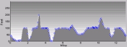
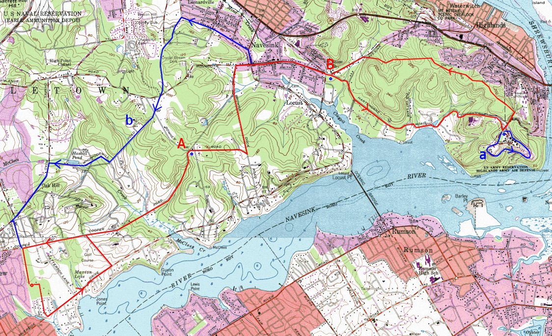
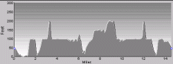
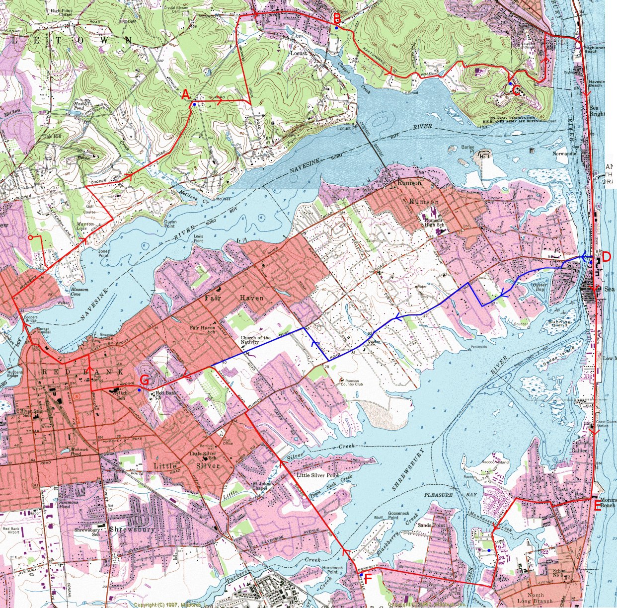
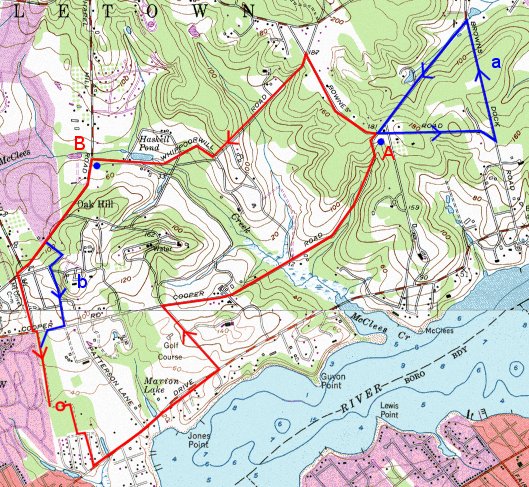
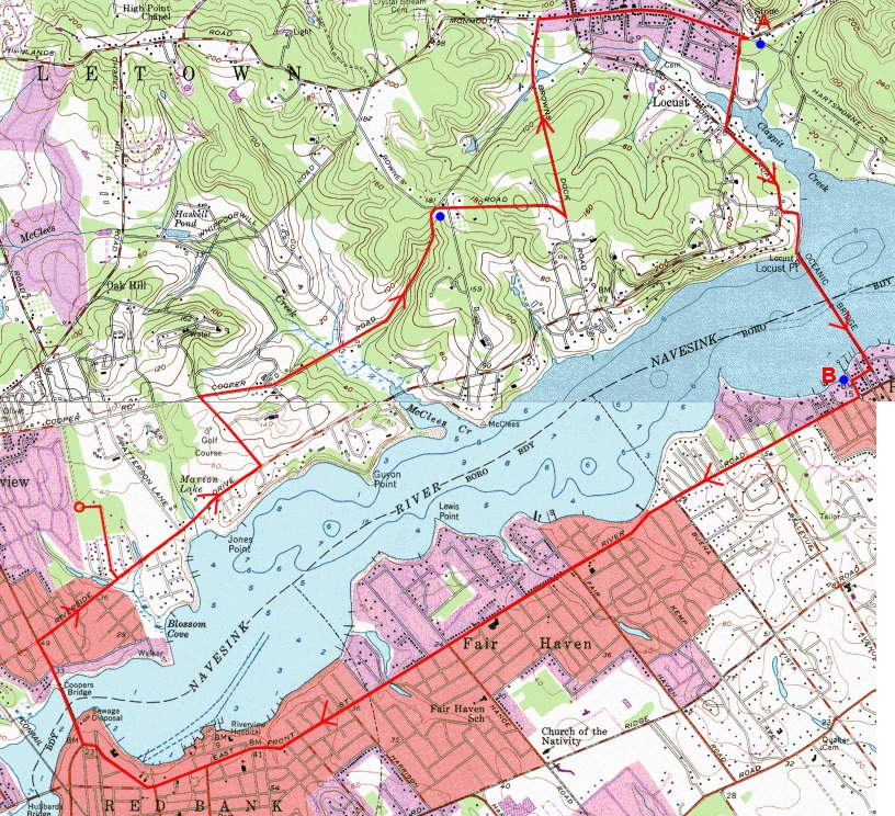
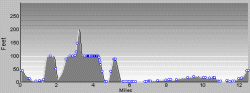
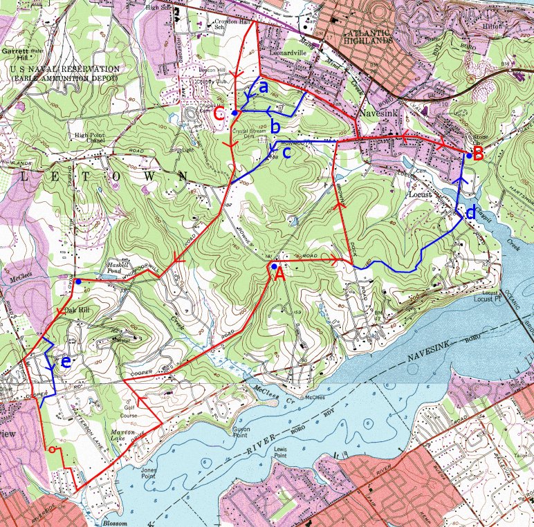
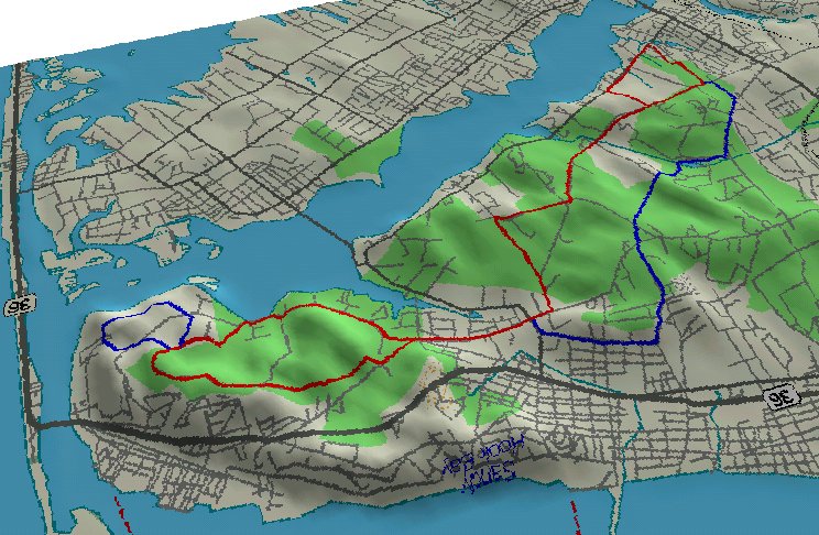
Total: 9.7 miles
Point A1: 3.0 miles
Point B: 5.2 miles
Point A2: 7.3 miles
Climb: 679 feet
Return via a: add 1.2 miles (10.9)
Return via b (Cooper): subtract 0.5 miles (9.2)
Return via c : add 0.7 (10.4)
Via Browns Dock both ways: add .2 (9.9)
Via Huber Woods both ways: subtract .2 (9.5)
StoneChurchHills.gif (5456 bytes)
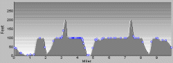
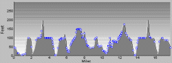
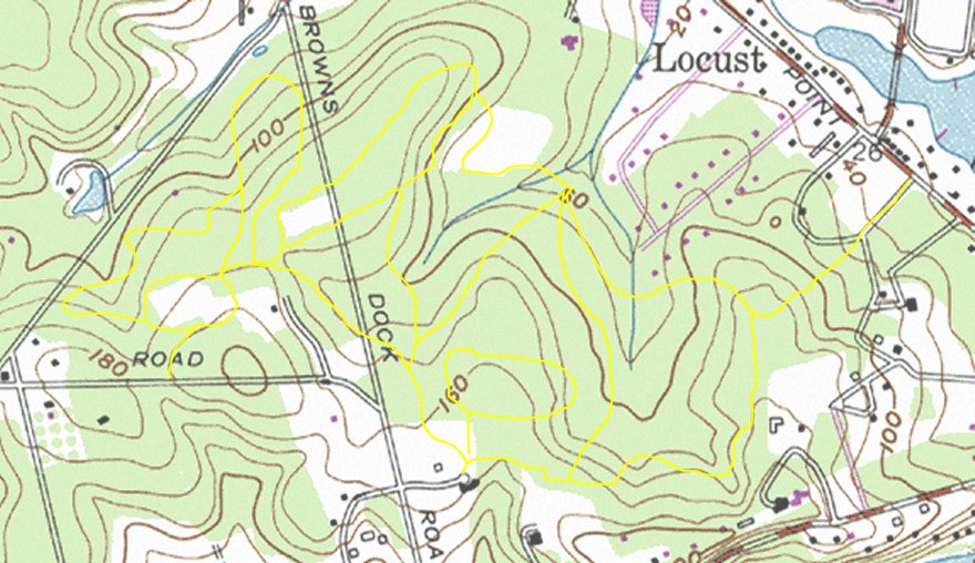
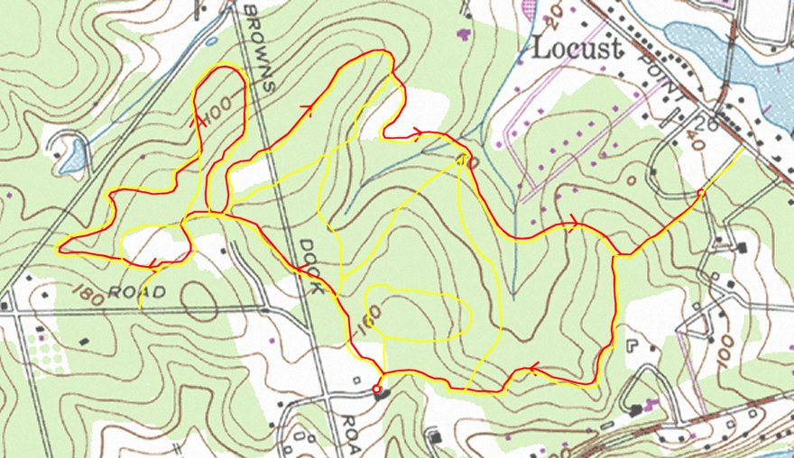
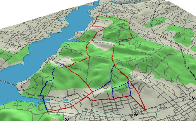
The "main" Sunday run for most club members, this travels through rural countryside, parks, and farmland.  Water stops are provided at points "A" and "B" (blue dots).  The one big hill on Cooper Road is more challenging on the outgoing leg of the trip; the return is much easier.

Here is a full-sized map.

Here is a 3-D view of this route.


Beacon Hill

BeaconHill.jpg

Total: 11.4 miles
Point A: 3.0 miles
Point B: 5.4 miles
Point C: 7.9 miles
Climb: 616 feet
Return via a (Portland): subtract 0.7 miles (10.7)
Return via b (Serpentine): subtract 0.8 miles (10.6)
Return via c (Whippoorwill): subtract 1.4 miles (10.0)
Via Huber Woods (d): subtract 0.2 mile
Via Independence & Hillandale (e): add 0.1 mile.
BeaconHillHills.gif (6007 bytes)
If the standard route is not enough for you, the return through Beacon Hill not only adds one and a half miles, but also adds a steep hill.  The difference between this run and the Stone Church route seems greater than the figures indicate. There are various ways to avoid the steep hill (which is just before point C), that also save a little distance.  Water and (usually) Gatorade is available at the top of Beacon Hill.

Here is a full-sized map.

Here is a 3-D view of this route.


Constitution

Constitution.jpg

Total: 13.3 miles
Point A: 3.0 miles
Point B: 5.4 miles
Point C: 7.2 miles
Climb: 643 feet
Return via a (Serpentine): subtract 0.1 miles (13.2)
Return via b (Independence): add 0.1 mile (13.4)
ConstitutionHills.gif (6007 bytes)
This variation on the return from the Stone Church adds a few miles and more hills.  Climb to the top of Beacon Hill by any of the standard routes (above).   Then go down through Beacon Hill golf course, along Leonardville Road, and up over the hill one more time.  You wind up back on Whippoorwill Road, not far from Beacon Hill, and return as usual.

Here is a full-sized map.


Hartshorne Loop

HartshorneLoop.jpg

Total: 14.6 miles
Point A: 3.0 miles
Point B: 5.4 miles
Point B (return): 9.8 miles
Point A (return) 12.2 miles
Variation a (Battery Loop): add 1.3 miles (15.9)
Return via b (Portland): add 0.5 miles (15.1)
Climb: 772 feet
HartshorneLoopHills.gif (5273 bytes)
This is a scenic variation to add a few miles to the standard run.   At the stone church, it takes a loop around Hartshorne before returning to the church.  The route shown here avoids the trails of Huber Woods, adding 0.2 miles and a big hill. The route through Huber Woods makes it even more rustic.

Here is a full-sized map.

Here is a 3-D view of this route.


Highlands

Highlands.jpg

Total: 8.5 miles (total 18.2)
Return via Whippoorwill: (18.3)
Return via Serpentine: (18.9)
Return via Portland: (19.0)
Climb: 673 feet
Return via a: 5.6 miles (total 15.3)
From Stone Church to B via b: 8.1 miles (total 16.8)
HighlandsHills.gif (6634 bytes)
This run starts and ends at the stone church, so that you can add it on to the standard run, or onto one of its variations.  When combined with the standard run, it comes to 18.2 miles.  When there is group running this on Sunday, they usually place water at the top of the hill in Hartshorne Park, at the jog in the road in downtown Highlands, and by the Hofbrauhaus Restaurant atop the cliffs overlooking the bay (shown as blue dots).  Returning through Atlantic Highlands via route b gives a total of 16.8 miles, when you finish up on Whippoorwill Road, as shown on the previous map (point C).

Here is a full-sized map.

Here is a 3-D view of this route.


Monster Loop

Monster.jpg

Total: 22.4 miles
Point A: 3.0 miles
Point B (Stone Church): 5.4 miles
Point C (Hartshorne): 7.6 miles
Point D (Gulf Station): 10.9 miles
Point E (Stoplight): 13.2 miles
Point F (Police Station): 16.2 miles
Point G (Tower Hill): 19.4 miles
Alternate Route G: 16 miles
Alternate Route Total: 19 miles
Climb: 618 feet
MonsterHills.gif (6216 bytes)
The aptly named "Monster Loop" has two versions: the full loop and the mini-loop.  The Jersey Shore Running Club seems to do this run about once a month, on selected Sunday mornings at 7:30.  The first half is hilly, and the second half has long stretches with no stops (both versions). There are several ways to cut the run down, depending on how you are feeling.  One thing I like about this run is the beauty and variety of the scenery.

Here is a full-sized map.

Here is a 3-D view of this route.


Inner Loop

InnerLoop.jpg

Total: 6.3 miles
Point A: 3.0 miles
Point B: 4.8 miles
Alternate a (Short Cooper): 8.0 miles
Alternate b: (Independence): add 0.1 miles
Climb: 312 feet
InnerLoopHills.gif (5058 bytes)
A shorter alternative to the Stone Church route, water is stashed at both points "A" and "B".  Much of the run is on back roads through rural Navesink highlands.

The extra loop on Cooper adds an extra hill.

Here is a 3-D view of this route.


River Loop

RiverLoop.jpg

Total: 12.6 miles
Point A: 5.2 miles
Point B: 7.2 miles
Climb: 484 feet
RiverLoopHills.gif (5775 bytes)
This run, which used to be the "standard" is now run on special occasions, such as the week before a marathon.  Instead of running along Navesink River Road, where the road is too narrow and the cars too fast, it goes through the back roads and farmlands to the Stone Church, then backtracks a little way to the Oceanic Bridge.  It returns through Rumson, Fair Haven, and Red Bank.  Unfortunately, there is no good place to stop for water after Rumson Park (point B).  There is an Exxon station in Fair Haven, but I have found that it is not always open early on Sunday morning.

Here is a full-sized map.

Here is a 3-D view of this route.


Hartshorne Trails

HartshorneTrails.jpg

The main trails in Hartshorne Park are shown in this map.  The Army Reservation shown on the map is now part of the park as well, and the roads in it are open to the public.  The main park entrance is on Navesink Road.  I prefer the back entrance, near the end of Hartshorne Road.  A third entrance is at Henry Hudson High School, just south of the Navesink Lighthouse

The Monmouth County Park System has their own map online, but the map in the brochure (available at many of the county parks) is better.


Hartshorne Runs

HartshorneRuns.jpg

Total: 5.5 miles
Point A: 2.3 miles
Point B: 3.9 miles
Climb: 540 feet
Blue trail adds: 1.8 miles
Blue trail climbs 200 feet
Front entrance: subtract 0.5 (5.0 miles)
A wonderful part to run in, because there are a variety of trails:   paved roads, dirt roads, and trails.  As shown on the red loop, you can run 5 miles without leaving the park or crossing your path.  The recent addition of new trails on the former military reservation adds another couple of miles to this total.   There are, or course, several ways to shorten or vary the run.  Be aware that there are a number of steep hills, and watch out of exposed rocks, root, and speeding bicyclists.

Huber Woods Trails

HuberTrails.jpg

Huber Park, with one entrance on Locust Point Road and the other on Browns Dock Road, offers several miles of running trails.  It is smaller than the nearby Hartshorne Woods, and is generally less hilly.  But in exchange, you will find more solitude, fewer bicycles, and a more intricate trail system.  In wet weather, it can be treacherous, so watch out.

Huber Woods Runs

HuberRuns.jpg

Total: 4.1 miles
Climb: 233 feet
There are many choices for runs here.  I have shown only the "outer" loop.  You can start from either entrance.

arrw10b.gif (371 bytes)Return to Running Map Summary