Places to Run -- Near Holmdel Bell Labs

Unless otherwise noted, these runs start at the West entrance of the Bell Labs building in Holmdel. Alternate versions that start at the East entrance are marked "E".


Line Loop

Line.jpg

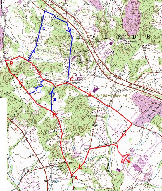
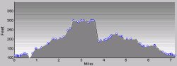
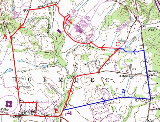
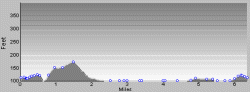
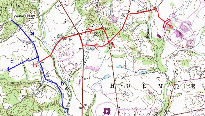
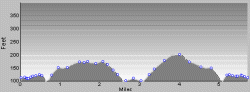
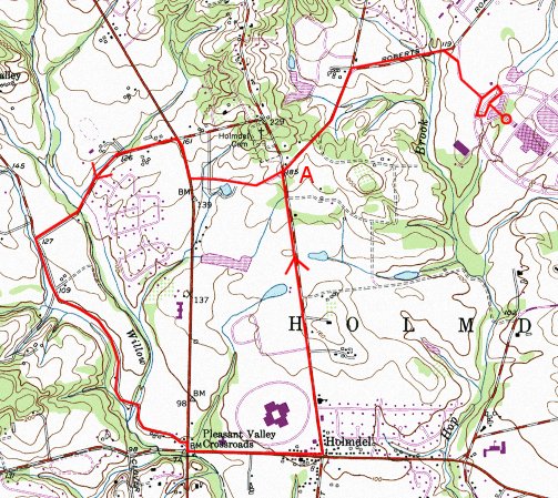
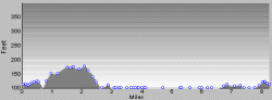
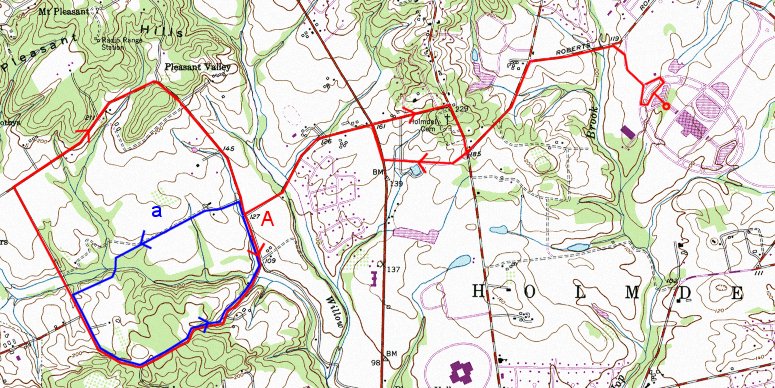
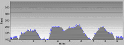
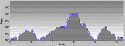
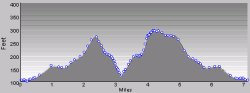
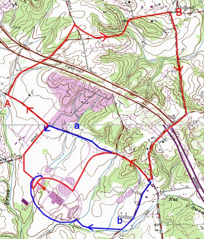
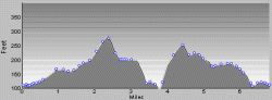
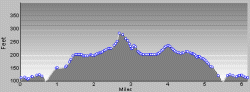
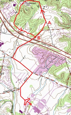
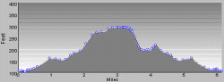
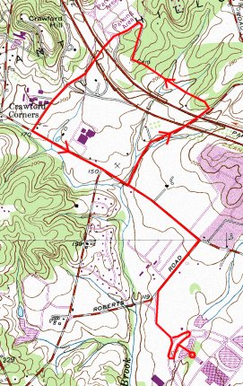
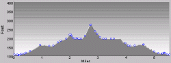
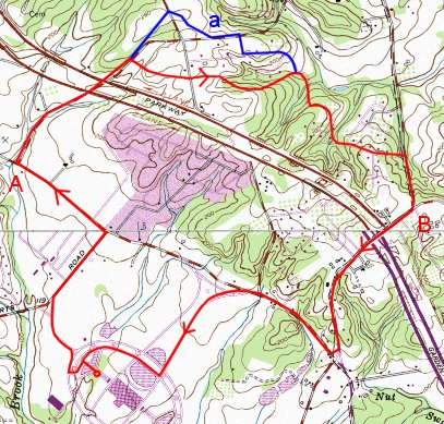
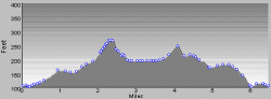
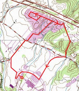
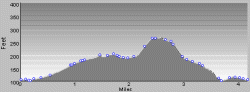
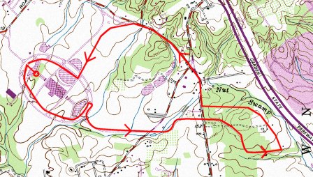
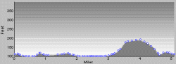
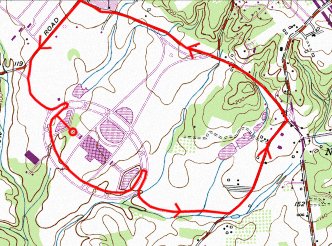
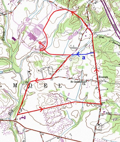
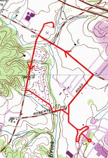
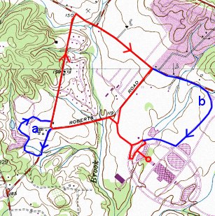
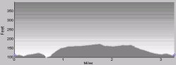
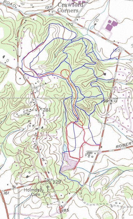
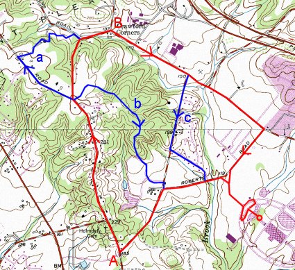
Total 5.5 miles
Point A: 1.5 miles
Point B: 3.3 miles
Climb: 238 feet
Return via a: 6.1 miles
Return via b: 5.0 miles
Return via c: 5.5 miles
LineHills.gif (4980 bytes)
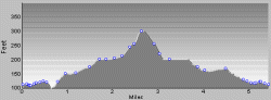
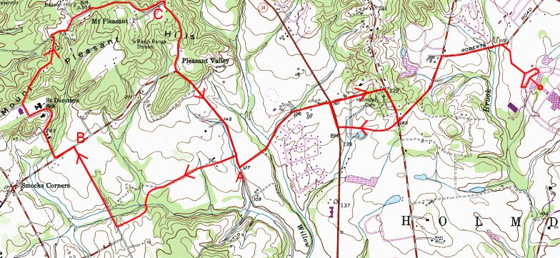
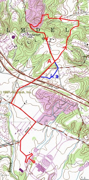
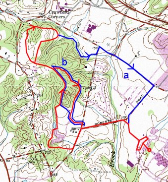
When run clockwise as shown, the one big hill is broken up into several gentle slopes.   If run the other way, the hill is much harder. Portions of the road are narrow and winding, with cars driving too fast: not for bad weather.  Add a little onto the Loop by following Line Road to Goldsmith Road, down to Van Brackle (a). Other variations are to come back through Holmdel Park (b), and to come back via Longstreet and Donner (c)

Van Brackle

VanBrackle.jpg

Total 7.2 miles
Point A: 1.5 miles
Point B: 3.8 miles
Point C: 5.0 miles
Variation A (Line Loop) 5.5 miles
Variation B (Goldsmith) 6.1 miles
Variation C (Beers-Crawford) 8.6 miles
Climb: 299 feet
VanBrackleHills.gif (4980 bytes)
A longer version of the Line loop combined with Crawford Hill.  There are two big hills to climb on this run.

The variations shown make this shorter or longer, as desired.


Crawford Hill

CrawfordHill.jpg

Total: 7.4 miles
Point A1: 2.2 miles
Point A2: 5.3 miles
Climb: 349 feet
CrawfordHillHills.gif (5601 bytes)
This run passes one of the older Lucent buildings in the area.

Holmdel Village Loop

Village.jpg

Total: 6.5 miles
Point A: 1.5 miles
Point B: 3.4 miles
Point C: 5.0 miles
Return via a (McCampbell): 7.8 miles
Climb: 131 feet
VillageHills.gif (5023 bytes)
Relatively flat run through some of the remaining farmland of Holmdel.  Little or no shade, can be tough on hot days.

T-Schanck

TSchank.jpg

Total: 5.8 miles
Point A1: 1.5 miles
Point B: 2.9 miles
Pont A2: 4.2 miles
Climb: 257 feet
Add on a: 7.4 miles
Add on b (to brook): 7.6 miles
TSchanckHills.gif (5210 bytes)
Another run through farmland, although increasingly less so every year.   Variations include side trips up (a) or down Pleasant Valley Road (b) as desired.   Another possibility is to explore the new developments under construction at the end of Schanck Road (c).  The road now goes through to Igoe, although one section is not yet paved.

Pleasant Valley

PleasantValley.jpg

Total: 7.5 miles
Point A1: 1.5 miles
Pont A2: 6.0 miles
Climb: 232 feet
PleasantValleyHills.gif (5266 bytes)
Another variation on T-Schanck, this run follows Pleasant Valley Road through farmland and forest all the way to the intersection of 520 and 34, then returns via Holmdel Road

Igoe

Igoe.jpg

Total: 9.6 miles
Point A1: 2.9 miles
Point A2: 6.7 miles
Climb: 415 feet
Return via a: 8.4 miles
IgoeHills.gif (5501 bytes)
The premier "long" run, through forest and farmland on the border of Holmdel and Marlboro.  Shade on the loop portion make it suitable even on sunny days.

Convent

Convent.jpg

Total: 11.0 miles
Point A1: 2.9 miles
Point B: 4.6 miles
Point C: 6.8 miles
Point A2: 8.1 miles
Climb: 489 feet
ConventHills.gif (5601 bytes)
Another great long run through the rural areas of Holmdel and Marlboro.  The convent is on Collier School Road, the first right on Pleasant Valley road after Igoe.  Continue through the school grounds, taking the back road leading off to the right.  After that, keep turning right until reaching Schanck.

Centerville

Centerville.jpg

Total: 7.1 miles
Point A1: 2.3 miles
Point A2: 4.8 miles
Variation a (Telegraph Hill): 4.8 miles
Climb: 381 feet
CentervilleHills.gif (5601 bytes)
After climbing to the top of Holland Road, continue down Takolusa to Centerville.  Return via Mount Drive.  There is no way to avoid the steep climb up Telegraph Hill, no matter which way you go around the loop.  But then it is downhill the last two miles.

For a shorter run, turn right at the top of the hill and return via a short side trip through the back streets.


Middletown Loop

Middletown.jpg

Total: 6.7 miles
Point A: 1.4 miles
Point B: 3.3 miles
Climb: 375 feet
Return via a: 7.3 miles
Return via b: 7.3 miles
MiddletownHills.gif (5267 bytes)
Climbs up and over Telegraph Hill, and drops down to the Middletown AT&T building, then climbs all the way back up to Red Hill.  Because of the hills, this run is more difficult than the mileage alone would suggest.  Possibilities for varying the ending: continuing on Middletown Road and entering the East Entrance (b), or continuing on Crawfords Corner Road, Roberts Road, and entering the West Entrance (a). 

Holmdel Park -- Bowl

Bowl.jpg

Total: 6.0 miles
Return via a (causeway): 5.4 miles
Return via b (skip bowl): 3.5 miles
Climb: 330 feet
BowlHills.gif (5400 bytes)
This run through Holmdel Park joins the 5K cross-country course just beyond the lake, and follows it to its conclusion near the park entrance.  On the way, it climbs one of the steepest hills in the vicinity.  An alternate return avoids this climb, returning instead along the stream and through the wetlands.

Arts Center 1

ArtsCenter1.jpg

Total: 6.3 miles
Point A: 2.3 miles
Point B: 4.3 miles
Climb: 253 feet
ArtsCenter1Hills.gif (5188 bytes)
This course climbs the highest hill in the area (Telegraph Hill), and descends through the forested areas of the Arts Center.  The route passes by the Vietnam Veterans Memorial.

Arts Center 2

ArtsCenter2.jpg

Total: 5.5 miles
Climb: 224 feet
ArtsCenter2Hills.gif (5188 bytes)
This goes by the Celebrity house and trail, and then passes by the Vietnam Veterans Memorial.  It exits through the commuter parking and the Holmdel roads department.

Galloping Hills

GallopingHills.jpg

Total: 6.4 miles
Point A: 1.4 miles
Point B: 4.1 miles
Climb: 276 feet
Alternative a: 6.5 miles
GallopingHillsHills.gif (5221 bytes)
This run is a variation on the Middletown Loop run, trading more steep hills for slightly less distance.  The cross section shown here is omits half a dozen very steep sections, making is more challenging than it appears.  There are numerous variations, one of which is shown here, involving different routes through the maze of residential streets. 

Catbird Alley

Carbird.jpg

Total: 4.2 miles
Climb: 208 feet
Alternate East/Front/Front: 4.6 miles
CatbirdHills.gif (5056 bytes)
A short run for those days when there is no time to run longer.  Also good for very hot days (plenty of shade), thunderstorms, or snow (sheltered, less traffic).   Can be shortened further if you are really in a hurry, or lengthened by returning via Middletown Road and the East Entrance.  Although it is relatively short, there are several steep hills (not adequately represented on the diagram on the left).

American Way

American.jpg

Total: 5.4 miles
Alternate East: 4.2 miles
AmericanHills.gif (5323 bytes)
Another short run for bad weather days.   Flat, relatively well sheltered run through residential areas.

Crawford Corner

CrawfordCorner.jpg

Total: 4.0 miles
Alternate from East/Front 4.1 miles
Another short run, essentially flat.

Everett

Everett.jpg

Total: 6.5 miles
Return via American way (a) 5.6 miles
This run is best done from the East entrance.

Track

Track.jpg

Total: 3.4 miles
Alternate East/Tower/Back: 4.8 miles
This is the normal route to and from the track at Holmdel High School.

Longstreet

Longstreet.jpg

Total: 3.3 miles
Variation a: add 0.7 miles 4.0 miles
Variation b: add 0.5 miles 3.8 miles
Alternate East/Front/Front: 4.7 miles
Alternate East/Front/Tower: 4.4 miles
LongstreetHills.jpg (3690 bytes)
A short run that is relatively flat.

Inner and Outer Loop

Loop.jpg

Outer Loop: 2.3 miles (door to door)
Outer Loop: 1.7 miles
Inner Loop: 1.7 miles (door to door)
Inner Loop: 1.5 miles
Water Tower: add 0.9 miles
For those times when you just don't have time to do more.

Holmdel Park Trails

HolmdelPark.jpg

This map shows the roads (red) and trails (blue) in Holmdel Park.

arrw10b.gif (371 bytes)Return to Running Map Summary