I have been experimenting with running carrying a Garmin eTrex GPS, in hopes of refining the actual layout of some of the trails in nearby parks, and partly out of curiosity about the gadget. The positional accuracy is not really good enough to use for trail maps, at least for the details. It actually does a pretty good job of tracking relative motion, but it often has much larger absolute errors. I guess these are due to Selective Availability, the deliberate degradation of the positioning signals by the military designed to deny an enemy precise navigation capabilities.
I wear a neoprene belt designed to fit carry a walkman. I put the eTrex unit in the pocket, and carry it in the small of my back. I try to have the unit ride vertically, facing out. Currently (in the winter) it goes under one or two layers of sweaty clothing. I don't know how, or if, any of these factors affects its performance.
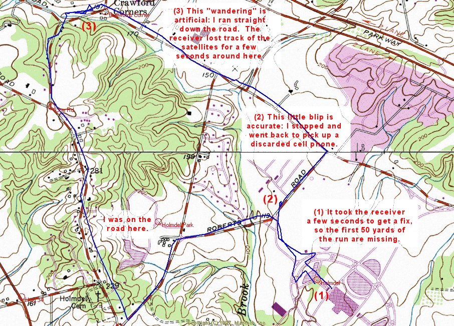
Here is one of the first tracks I recorded, plotted on a topo map. It shows me running parallel to the streets in some cases. I assure you that I was on the roads at all times, and that these deviations represent inaccuracies in the GPS. Click the image to see a larger version, which has some notes on specific features of the track.
This is a detailed analysis of one run, taken on Feb 20, 2000. The run lasted three hours and covered 20 miles. The weather was clear, the temperature about 30 degrees at the start and 38 degrees at the end. I wore the eTrex against my body, as described above, and did not take it out or fiddle with it during the run.
The following analysis shows each of the twelve places where the eTrex lost contact with the satellites, and all the places where there were significant deviations from accurate tracking. The twelve gaps amount to less then two minutes in the three hour period, and represent pretty good performance in my opinion. The inaccuracies, at times up to 750 feet, are less acceptable. I added up the distance of all 492 segments, and it came to 18.7 miles. I measured the course I ran carefully on a map (using Terrain Navigator software) and got 20.2 miles. This is a distressing discrepency.
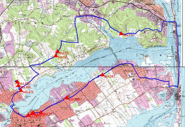
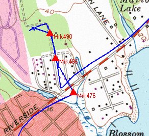
The map above shows the circuit, starting near the lower left and continuing around clockwise, back to the start. The twelve gaps in coverage are marked by red triangles and the segment number that was missing. The first few miles of the run are through rural farmland and parks, where there was often moderate tree cover. I then crossed a bridge and ran along the beach. Crossing back, the run went through suburban residental neighborhoods, then going through downtown Red Bank, where there were many 2-3 story brick buildings.
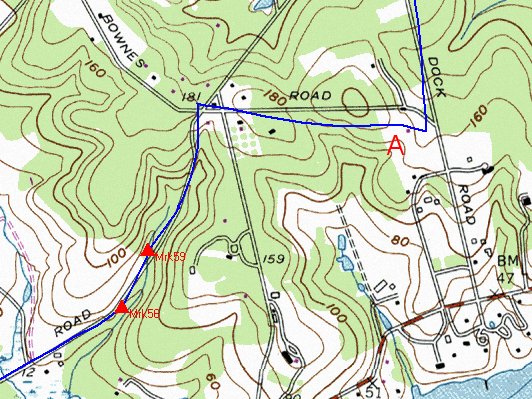
The first time satellite contact was lost was beside an open field, just before entering a forested valley. I cannot explain why there was difficulty here, though the unit maintained excellent accuracy along this stretch of road. Just a little later, near point A, thr track deviates significantly from the road shown on the map. This area was forested, so maybe the accuracy was degraded without losing the signal entirely. I figure the track is off by about 200 feet at most.
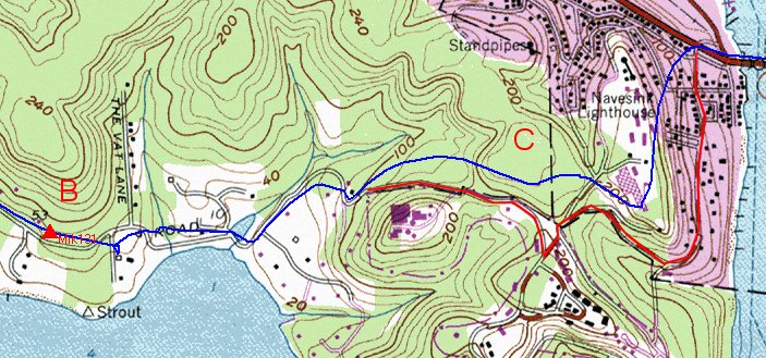
The next time satellit contact was lost was several miles later. The accuracy over the preceeding few miles had been about 50 feet in the open, and about 100 feet where there was tree cover. Near B the signal was lost again, and the track shows some hunting around afterwards. A little farther on, near C, the road turns to a trail and travels through forest. Although sateelite contact was maintained, the track was way off. The red line shows the actual path I travelled. The track if off by about 750 feet at one point. In the purple section, the route was in a residential neighborhood on a steep hill overlooking the ocean. There were no significant obstructions to explain the loss of accuracy. Perhaps it was affected by the steep hill ?
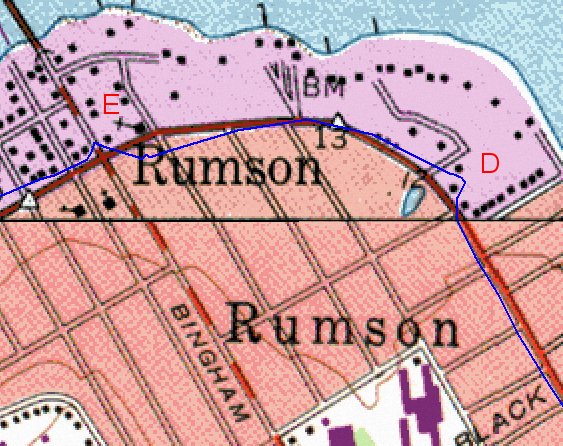
The unit performed well along the beach, generally tracking my actual path within 100 feet. This continued as I crossed into residential neighborhods. The map above, at twice the magnification of the other maps here, shows a couple of "glitches," at D and E. These represent my actual path. At D I crossed from the left side of the road and ran around behind the Rumson City Hall (the black square) looking for a drinking fountain. At E I again crossed the road and ran up to a building, still looking for a drink.
The receiver lost the signal again in a sparsely-populated residential neighborhood a mile past the previous map. I have no good explanation for why. You can again see the receiver hunting around before it achieves its former accuracy.
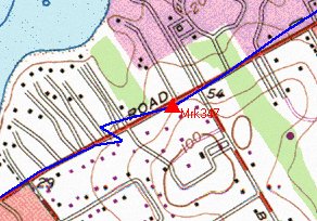
In this section, the track gradually strayed from the road (where I ran). At the most, it is off by about 375 feet. It lost the signal entirely when I entered a gas station to get a drink of water. After I emerged, it looks like it got a much better fix on its actual position. This example, together with the track in detail map 2, suggest that the receiver acts as though it is slowly drifting off course. I thought the GPS system was broadcasting absolute position coordinates, with the position being recomputed every time. These experiments make it appear as though it is integrating relative changes in position.
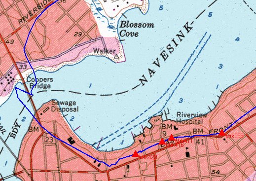
This section gave the receiver lots of trouble. It lost the signal four times in downtown Red Bank, in the vicinity of several 5-8 story buildings and 2-3 story storefront buildings. Still the track was pretty accurate until I crossed Coopers bridge. This bridge is under construction, and there were a couple of steel cranes on barges in the water next to the bridge. I don't know what else could explain the erratic track. My actual path was over the bridge, and right on Riverside. It looks like the eror here was at least 300 feet. Interestingly, it did not report any loss of signal during these gyrations.
At the very end of the run, the unit lost track of the signal three more times. Again, I have no explanation for the reason -- this area does not see much different from the other places I had been.
![]() Return to Home Page
Return to Home Page